Marine Systems

Maritime industries such as shipping, dredging, fishing, offshore oil and gas continue to grow in response to rising incomes and population growth. Newer sectors such as offshore deep-water oil and gas, renewable energy, Mari culture and seabed mining have begun to play a major role in the economy. The growth of a sustainable global economy will be constrained unless we develop integrated systems for marine environment monitoring supporting efficient management of marine resources.

Marine environment monitoring systems have to withstand complex and harsh operating conditions. Gathering data from marine environment is both complex and expensive operation. Our portfolio in this area consists of development of marine and harbor systems, marine surveys, software and hardware development, database and collection systems, modeling and forecasting, early warning systems. As a certified research organization we participate in various research projects results of which assist our continuous product development.  

Our core customer groups include, but are not limited to, marine operators, coastal management authorities, environmental agencies, meteorological departments and offices of civil protection.

AUTOMATIC MARINE STATION

  • Modular and scalable platform for additional sensors and future upgrades
  • Statistics, alerts and notifications based on user-defined parameters
  • Multimode data communication
  • Customizable web interface
Image
Image

IMS4 HELIDECK MONITORING SYSTEM

Built on the modular and field proven IMS4 AWOS platform, IMS4 Helideck is optimized to provide real-time weather conditions and monitoring of the helideck motion, thus ensuring the flight and passenger safety.

The weather parameters monitored include wind speed and direction, air and sea temperature, relative humidity, barometric pressure, visibility and present weather, cloud height and wave height. In addition, the IMS4 Helideck monitors the helideck’s heave, heave velocity, roll, pitch and inclination in real-time. The automatically generated helideck reports can be disseminated through various communication channels or optionally broadcast to pilots via VHF transceiver.

Image

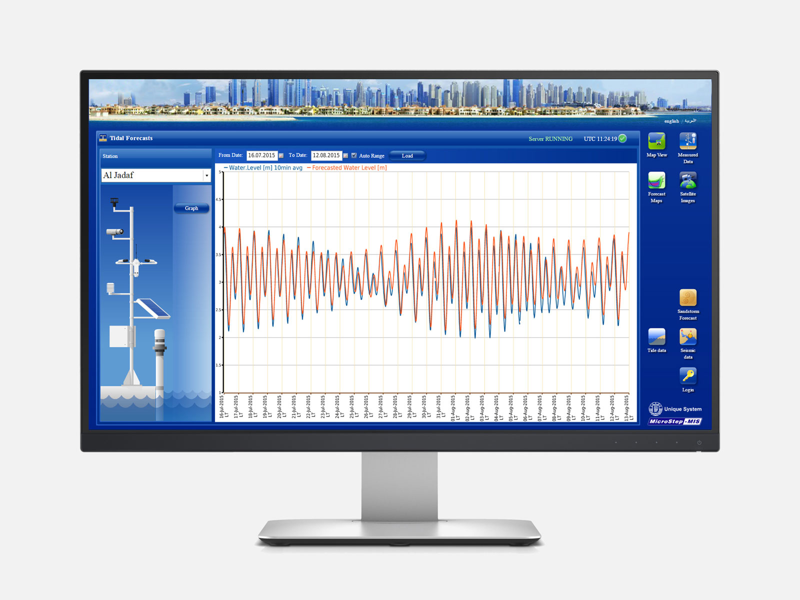
MARINE MODELING AND FORECASTING

For studying and modeling motion of water, IMS4 Marine could be integrated with 2D & 3D marine models. The marine models are tightly coupled with IMS4 Marine and the model outputs can be viewed as well as saved to a unified data platform for further analysis and data QA/QC.

Customized front end displays and tools could be developed for interacting with the marine models like obtaining data from the model such as water level or current at a particular position, as well as extracting time series data, option to draw a transection to visualize profile graphs like for surface current. Animation of marine parameters such as velocity, surface elevation changes over time could be prepared and presented with user friendly displays. Forecast assessment is included in the system.

  • IMS4 ATTIDE - CUSTOMIZED TIDAL ANALYSIS AND PREDICTION SOFTWARE
  • WIND-WAVE MODELS
  • 3D MARINE MODELS FOR FLUSHING AND SEDIMENT TRANSPORT STUDIES
  • MARINE FORECASTING SOLUTIONS

MARINE SURVEYING AND HABITAT MAPPING

Image
Hydrographic / Bathymetric Surveys
IMS4 Marine could be integrated with bathymetry survey data and generation of Digital Terrain Model (DTM). Integrating with the local bathymetry enables fine tuning of the marine models for better representation of the model domain. Integration of the bathymetry allows development of localized operational models for applications such as oil spills, search and rescue, flushing scenarios and sediment transport studies.

Marine Geophysical Surveys
We conduct marine geophysical surveys, to identify existing subsurface structural features, geological layers, and/or buried wreckages, and infrastructure. Marine geophysical surveys can help project stakeholders to identify subsurface conditions that might otherwise remain hidden to traditional bathymetric survey techniques and underwater investigations by divers.

Marine Cartographic Solutions
We produce navigational charts for navigation purposes and entering channels and ports, in addition to show coastline configurations and the bathymetry of coastal waters. Moreover accurate charts are essential for proper planning in support of multiple usage of maritime resources within national waters. Collection and analysis of field data, and the transposing of this data on to charts becomes an essential navigational tool for the maritime industry.

Biodiversity Surveys
Biodiversity is the variety of life forms found on Earth but this biodiversity is fragile and easily threatened. Human activities such as buildingg development and external factors such as climate change put even more strains on it. Biodiversity surveys are undertaken to find out what organisms exist in a given area. And it is a research tool that help define areas and species of most conservation value and need, and also provide data to allow effective monitoring and evaluation of implemented conservation measures.

Marine Habitat Surveys
Habitat surveys are conducted using multi-beam sonars, echo sounders, and remotely operated vehicles. With these surveys, scientists map, explore and document the physical, chemical, and biological systems. The data can be collated with other habitat and bathymetry data and integrated in IMS4 Marine to model and map the distribution of the marine habitats. IMS4 Marine maps can be used to quantify the spatial area of the marine habitats and to monitor whether the distribution changes over time.

Environmental Studies
The world is becoming more crowded, more consuming, and more connected. Human activities, growing populations and higher standards of living put increasing pressure on our environment. Therefore we are doing environmental studies to know how physical and biological processes maintain life, and how humans affect nature.

GET IN TOUCH

With our professional team and quality tools & equipment, we have the capacity to design, develop, install and commission reliable, effective and efficient Weather Monitoring solutions on any scale. Get in touch with us and let us know how we can help you achieve communication efficiency.


We are one of the leading providers of Wireless & Navigation, Voice and Data solutions with over 15 years of experience. We are also the official authorized Garmin Distributor in Tanzania providing innovative and exciting products.

Downloads

  •   (255) 772 775 775
  •   (255) 687 887 225
  •   (255) 784 531 153
  •   salescentre@radiowave.co.tz
  •   sales@radiowave.co.tz